
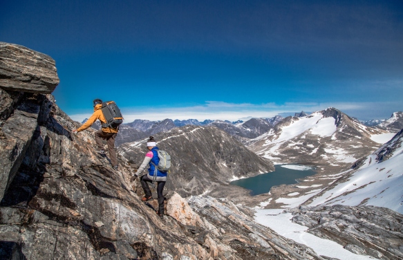
Beginning to scramble/use hands on the way up. Photo by: Raven Eye Photography – Visit Greenland
The rush you get standing on top of a mountain is a special kind of adrenaline. Photo by: Raven Eye Photography – Visit Greenland
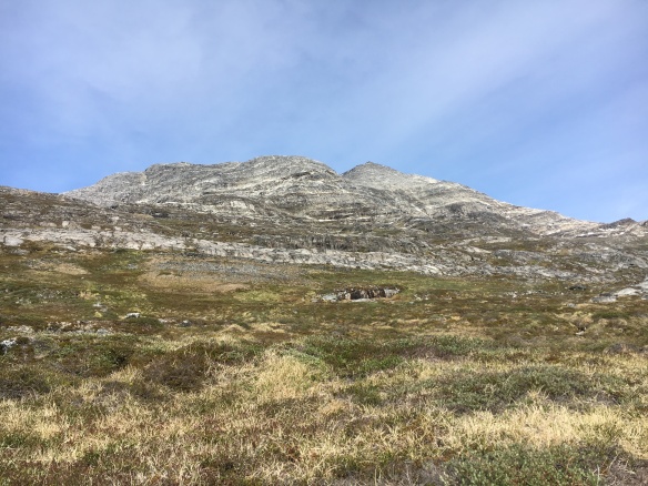
KINGITTORSUAQ is proof that there’s BIG adventure in Nuuk, the Arctic Metropolis of Greenland. It is one of the four mountains in the city’s immediate vicinity that most residents know by name. (The other three are: Ukkusissat, Quassussuaq and Sermitsiaq). While most locals will take Ukkusissat as a Saturday morning or even after-work fun trip, sometimes you just want something a little more extreme.
SEE TO THE BOTTOM FOR SOME QUICK BITS ABOUT WHY KINGITTORSUAQ IS MORE DIFFICULT YET MORE EXCITING THAN THE STANDBYS.
My Hike on Kingittorsuaq
Three weekends ago (on 18 June 2016) I had the privilege to hike Kingittorsuaq mountain for the second time. The first time I hiked it was back in June 2012, so that shows you how infrequently this opportunity tends to come along without special circumstance.
Here’s some photographs from the trip. I think the two best experiences of the whole day were 1) cresting at the ‘saddle’ for a view over snow-capped peaks that even fooled Greenlanders into thinking it was the tough and rugged mountains of East Greenland, and 2) taking a quick polar plunge in a little meltwater swimming hole near the summit!
 Hiking from sea to summit is no small feat. Sometimes one thinks, “Can I REALLY do this?” The answer is Yes, you can! Just put one foot in front of the other. The bottom half of the mountain is grassy/mossy/shrubby terrain, which I personally think is tougher on the legs than the rocky part.
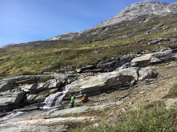 And anywhere there’s lush green terrain, there’s fresh running water sources. It’s special about Greenland to be able to drink directly from a stream or waterfall. Here we are at approximately 219 m / 719 ft above sea level.
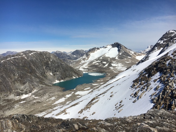 Spectacular outlook point from the saddle at approximately 800 m / 2625 ft above sea level. This is the shot that made some locals think it was East Greenland! The first of two best experiences of the whole day.
 Here solidly into the rocky terrain, between 800-900 m / 2625-2953 ft above sea level, looking southward. It’s scrambling / bouldering from here on up, with more than a few narrow passes.
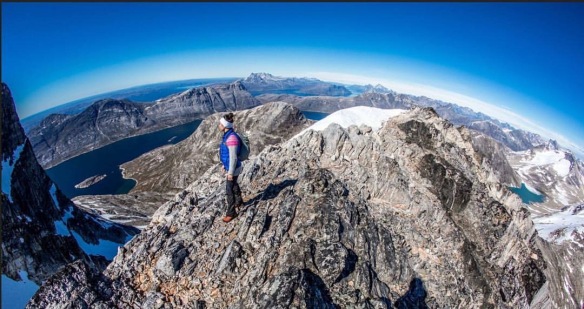
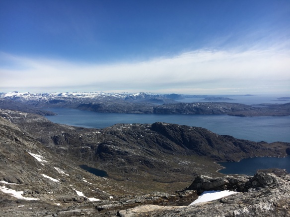
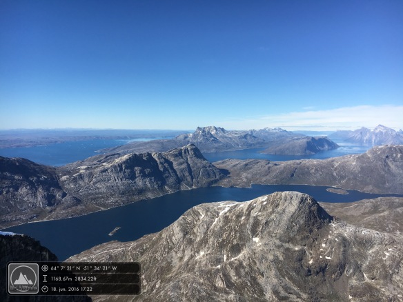
 My favourite perspective, actually. There’s something about the steep wall of Kingittorsuaq in the foreground, Kangerluarsunnguaq fjord in the middle ground, and Nuuk Fjord beyond. You can see everything. Approximately 1169 m / 3834 ft above sea level.
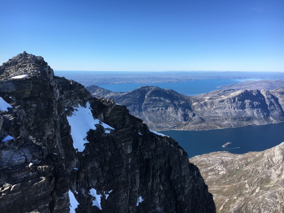
 So beautiful and clear day. Feels like you could see all the way to Canada. Looking north into Nuuk Fjord. Four hours into the hike.
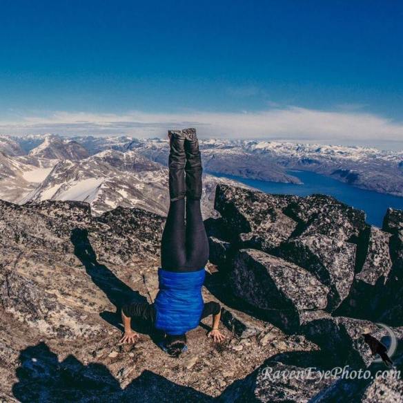 Beautiful overlooks deserve a yoga moment. Photo credit: Raven Eye Photography.
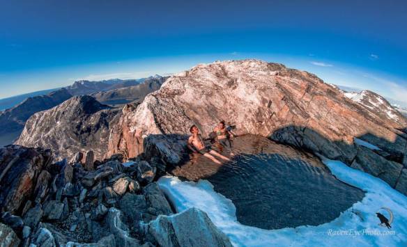 And little ponds of snowmelt deserve a quick dip. No, it wasn’t the slightest bit warm, but sometimes you just know when you’re NEVER going to get the same chance again, so it’s now or never. The other best experience of the entire day. Photo credit: Raven Eye Photography.
So there you have a digital tour of hiking Kingittorsuaq in Nuuk, Greenland. Want some more info to decide if Kingittorsuaq is right for you? Read below.
Why Kingittorsuaq is more difficult than Ukkusissat:
- It’s taller by approx. 410 meters / 1345 feet. (Ukkusissat is 780 m / 2559 ft and Kingittorsuaq is 1190 m / 3904 ft).
- The top half (rough estimate) is pure bouldering/scrambling (i.e. you must use your hands to climb up) and, in some places, involves some “tight rope walking” along narrow passes.


Nearly to the true summit of Kingittorsuaq. The left picture is a view northward into Nuuk Fjord. The right picture is a more westward view; Nuuk city is behind the mountain in the middle ground, Ukkusissat.
- There is no marked route, no slightly-trodden trail. You should absolutely go with someone who knows the way.
- There are a lot of (sharp) loose stones and rocks in the top half. You must constantly pay attention to your hand placement and footing, and as one of my hiking partners noted, the conversation definitely dies down a bit as everyone starts concentrating more.
Why Kingittorsuaq is more exciting than Ukkusissat:
- Kingittorsuaq one of the less-hiked mountains in Nuuk, so there’s absolutely a feeling of exclusivity and remoteness. The first time I hiked it, our group of 3 women + 1 man was the only group out there. This time, our group of 2 women + 3 men met just one other group: 4 men.
- There’s a built-in sailing experience to get to the starting point. Unless, of course, you want to start with a 30 km walk or run through the Nuuk backcountry and Kangerluarsunnguaq lowlands – which, by the way, IS a thing. It’s called the annual KangNu Race, which I have run twice, both in the short version and in the seriously hard long version! To sail to Kingittorsuaq like most people, you have the option of hiring a boat charter via Nuuk Water Taxi and then hiking on your own, or the other option is to purchase the experience as a ‘tour’ from a local operator, either Nuuk Adventure or Inuk Expedition.
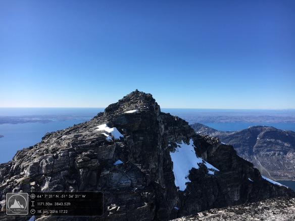
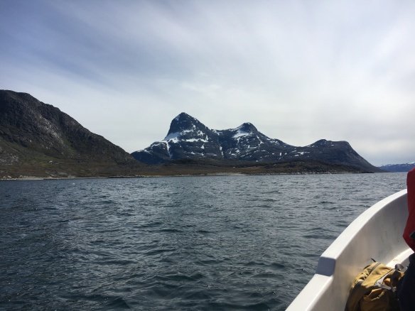 Kingittorsuaq is the double-peaked mountain. The left peak is, clearly, the higher of the two and is the true summit.
What to wear/bring with you in your daypack (NOT an all-inclusive list):
- Breathable/ quick-dry layers, never cotton. Being able to regulate your body temperature ever so slightly with several thinner layers is infinitely more valuable than having one or a few thicker layers. For this particular day (light wind 10 m/s or less, air temperature around 5-10*C) I wore long running pants, a breathable short-sleeve shirt, a lightweight wool-blend long-sleeve base layer, a lightweight wool sweater (which came off and on periodically), and a ultra lightweight vest. Also a thin Buff headband. At some points I did take on a pair of gloves when I could feel my fingers were a bit slow reacting. It’s also good to have an extra pair of wool socks, and at least one extra layer along with you as backup.
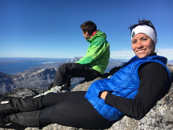 Taking in the sights at 1170 m / 3842 ft on Kingittorsuaq. FANTASTIC view over the entire world, it feels like. Note the clothing.
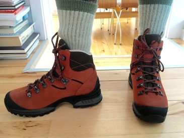
- Sturdy hiking boots with good ankle support, preferably waterproof. Good footwear simply cannot be stressed enough for hiking in Greenland. The granite in these mountains is rough and sharp, and it’s not really an exaggeration to say that it can eat the soles (and souls) of cheap or old hiking boots.
- Lunch. It can take a fitter-than-average person around 4 hours to reach the summit, plus nearly the same amount of time to get back down, so you will want to have plenty of energy store. Don’t let yourself get hangry. Chocolate and nuts are always good mountain snacks, but a slab of smoked Greenlandic reindeer meat is also perfect for the trip. When in Rome…
- Water bottle. There are several places to collect fresh drinking water directly from runoff streams, and it tastes so refreshing!
- Hat and gloves. Yes, even in summer a light wind can make it quite cold. It’s especially important to protect the dexterity of your hands given how much bouldering/scrambling you’ll be doing at higher altitudes.
- Gaiters. Useful at the bottom half when traipsing through low brush and at the top half if there should be any snowy patches. At the very least, they can be an extra layer of lower-leg protection against mosquito bites.
- Mosquito net hat. Speaking of… Arctic summers are notorious for mosquitoes and flies, and they can be especially gruesome when there’s little or no wind.
- Sunglasses and sunscreen. High latitudes plus high altitudes are the perfect combination for getting a lot of color on your face in just a few hours. Add in the sun’s reflection off of snow, and you’ve got a perfect combination for sunburn. Protect your skin and eyes!
How to Get Here
- Fly through ICELAND.
- Air Greenland flies direct from Keflavik International Airport to Nuuk International Airport (3 hour flight).
- Air Iceland Connect flies direct from Reykjavík Domestic Airport to Nuuk International Airport (3 hour flight).
- Fly through DENMARK.
- Air Greenland flies from Kastrup/Copenhagen International Airport to Kangerlussuaq International Airport in Greenland (4 hour flight) and then on to Nuuk International Airport (1 hour flight).
For more hiking inspiration and information, ready my Ultimate Greenland Hiking Guide on visitgreenland.com.

Pingback: PHOTO GALLERY: KangNu Race: Running in Nuuk Backcountry | Adventures of a Polarphile
Wow, these pictures are gorgeous! Thanks for posting these!
I’m planning to go to Greenland in May and after looking at your blog, I definitely want to do this hike.
How did you get to the starting point? Did you rent a boat for the day or use the Nuuk water taxi? I looked up the Touring-Greenland website, and they don’t appear to be in business anymore.
Also, how technical is the climb during the scrambling portion at the top and how steep would you say the grade is beneath you? Is this something for which you’d recommend bringing climbing gear, or just a steep hike where you need to use your hands somewhat?
Hi Stephen,
Thank you for the readership, and I’m glad I can inspire others!
Yes, unfortunately Touring Greenland has decided to sell off the ‘regular tours’ and focuses only on their luxury adventure camp, Kiattua. Thanks for making me aware that this link still stands here. I will fix that.
Nuuk Water Taxi could certainly be an option as the transport for a non-guided trip.
If you wanted a guided trip, Inuk Expedition is doing this one (http://inuk.dk/home/hjortetakken.html). The website is unfortunately only in Danish, but the owner and guide, Nick Nielsen, can speak/write to you in English. His website actually shows the sailing route on the map, too.
Another option for a guided trip would be Nuuk Adventure (https://nuukadventure.gl/) who partners with Ittu.net for the boat transport and then the owner, Marc Carreras, does the guiding.
Regarding the technical grade – climbing gear is not necessary; it is more a ‘steep hike where you need to use your hands somewhat’, as you inquire. However, at the very tip top where there is persistent snow 365 days a year, it is a very, very good idea to have poles where you can test the depth of the snow and the presence of solid rock underneath.
Best,
Sarah