Town walk in Qaqortoq: to the top of the hill

Qaqortoq has so many surprising stone sculptures, little nooks and aesthetic touches – it really is one of the most charming towns in Greenland to walk around in.

There are several recommendable walking tour loops, but a definite must-do is to the top of the hill to get the eagle-eye view over the whole town, the lake and out to the open ocean. Consider this one a heart-healthy workout; it is a good 15-20 minutes up, and from personal experience, you won’t want to be overdressed. But just take a look at what awaits you up there! This view never, ever gets old.

IMG_4256

A view over parts of Qaqortoq - the largest town in South Greenland Photo by: Mads Pihl / Visit Greenland

Here’s a visual guide for how to get up to the top of the hill using shortcuts instead of following the road with several switchbacks. Note: I don’t use street names because, to be honest, locals never use street names – only landmarks 🙂

There are two main accommodations in town, Hotel Qaqortoq and Siniffik Inn (plus a handful of private AirBnB properties), so I’ll give you a head start from both. They’re very close to each other anyway.

From Siniffik Inn, you will walk down the hill of your road and come to the main intersection with the red municipality building, white church and blue grocery store (Brugseni) directly ahead of you. Turn left. (Then, you will soon pass the hotel on your right.)

IMG_4216


From Hotel Qaqortoq, you will go out the front door and turn right at the red Tele Post post office building. Now everyone is on the same track anyway.

IMG_4217


After passing the Tele Post post office on the right, continue toward the intersection. The big red complex (RockHouse bar) will be on the right. Cross the road veering right, and then turn left. The green Police Station and the blue Pisiffik Elia grocery store will soon come up on the left, and after that, the Ajarsivasik retirement home on the left.

IMG_4218


The Ajarsivasik retirement home will be the final commercial landmark on this route. From here on up, it’s completely residential.

The first shortcut you will take will come on the left, at just about the middle of the curve. Look for this yellow house, and turn left up the hill.

IMG_4220


When you reach the road, veer right to find the beautiful stone stairway that continues upward. There is a bus stop sign at its foot.

IMG_4221


At the top of the stone stairway, cross a small little side street and then immediately after that cross the main road, turning into a little cluster of houses. If you feel like you’re encroaching on someone’s property, don’t worry; this is the normal route all the locals take! Not to mention, there is no private land property in Greenland. People own the houses themselves, but not the ground they stand on.

IMG_4222


After entering the cluster of houses, again, veer right and find a wooden stairway to the left. Up, up, up. Don’t forget to stop and look behind you to check how the view improves along the way!

IMG_4223


At the top of the wooden stairway, walk up the small driveway toward the main road and find the final wooden stairway (green) of this endless hike to heaven!

IMG_4224


At the top of the stairs, you will see a white house with a mural of a polar bear. Here, turn left if you want to reach the very end of the road in Qaqortoq, or weave between the houses a bit to climb the last little portion on terrain to get to the very tip top of the hill.

The view is worth the workout, trust me.

IMG_4225


And if you go a bit before sunset, you just might capture something like this. Enjoy!

img_2552

Happy New Year, from South Greenland!

img_1778

One year since my last blog post… well, that’s embarrassing. But as I have informed before, these days I am SO much more active on Instagram. Instagram is just much easier with little blurbs and a picture, and stories – voila. Follow me: @polarphile. That being said, I will *try* to be a little more active here where a full length story is necessary.

The greetings come from South Greenland because we moved!! More on that below…

Well, I cannot and will not go through an entire year’s worth of events (that can be seen ad nauseam in Insta), but suffice it to say that 2018 was pretty much 300% focused on Nakuak’, the ship my boyfriend and I bought in connection with the sailing company we started last January. We are above water (pun intended) but still in upstart phase, thanks for asking.

I spent all spring, summer and early autumn in work overalls getting down and dirty with rust removal, motor room tasks and painting projects. When I look back, that is ALL I can remember. At least she sparkles reallllllllll pretty now 🙂 Our last day onboard before the winter freeze over was 6 October. As in, it began snowing on the 7th.


But I did a little exercise on Instagram (mostly to remind myself) of making a Year in Review picture collage that accurately represents the year in its totality. There were four trips to Ilulissat (one of which was sailing with photo tourists with my boyfriend’s father) plus a few private sailing trips/weekend fjord getaways of our own around Nuuk; we spent a month in Qaqortoq getting our official Boat Captain licenses complete with courses on navigation, long-range radio operation, elementary firefighting, safety at sea and first aid; we took a jaunt to Sweden; the normal dinners with relatives and coffees with friends; plus there were three additional quick trips to Qaqortoq and last but not least the big finale to the year was… we MOVED to Qaqortoq permanently, in mid-November.

skærmbillede 2019-01-15 kl. 15.14.02

So it’s therefore this New Year’s greeting comes from South Greenland! It has been amazing to compare this region to the Capital and the North that I know so well. Qaqortoq lies at 60* north latitude, which is about 670 km / 400 mi south of the Arctic Circle. And in relation to Nuuk, we are now 440 km / 270 mi further south. It’s quite a ways! It’s also much smaller. There are 3015 residents here (as opposed to 17.000 something) and only about 5-7% of the residents are foreign-born (compared to nearly 30% in Nuuk, the capital).

Most noticeably for me, the temperature here was like summer (ok, “this year’s Nuuk summer”) until not that long ago – hovering at just about 0* Celsius or a few degrees above / 32-40* Fahrenheit. In fact, I was in serious crisis wondering if we were going to have a white Christmas or not!! It really affected my mood, to be honest. And some days, it was hard for me to remember that we were actually still in Greenland. Thankfully, it did begin snowing on Christmas Day (25 Dec) itself. And this week we’ve had many days in a row with consistent snow all day long.

Here’s a visual depiction of the big impressions from our first couple of months at South Greenlanders…


TREES & HUGE NATURE! South Greenland has two whole forests, actually. This one is in Narsarsuaq, and there’s another in Tasermiut Fjord. It’s fun to walk through the Narsarsuaq arboretum during a layover, and even more fun if you get a delicious to-go coffee drink from Cafe Polar-tut and enjoy it amongst the colourful trees. And those snowy peaks of the mountains toward the southernmost part of South Greenland – I was blown away by how gorgeous it was in autumn!


THAT VIEW! THOSE SUNSETS! Life at the top of the town’s hill certainly has its perks, namely a fantastic view over the whole town and out to the sea. That was really important to me. One’s biggest inspiration can also be one’s biggest distraction. You have no idea how hard it is to not just stare out the window all day long! And when sunset time comes (in the 15.00 / 3:00 PM hour in late autumn/early winter), you can definitely count on not being able to do anything other than stand on the terrace and take photos for an hour.


A BEAUTIFUL PLACE TO LIVE! The town is filled with little gems like cobblestone stairways, little benches to stop for a spell, old houses in the town center whose structure clearly takes from the German missionaries and artwork carved out of rock walls at every turn. One day I will do the full art walk throughout every street in the whole town.

I hope to write again soon. Until then, see you in Instagram 😉 


Autumn adventure along the Arctic Circle, Part 1

You know you’re in one of the best jobs on Earth when… it sends you to guide international agents through 200 km of the Arctic Circle from ice cap to coastline. It was a five-day adventure that (almost) made me and the 7 agents forget we were working! Read about my extended weekend of new experiences here.

In mid-September 2017, on home turf, Greenland hosted Vestnorden Travel Mart, a trade show to connect international travel specialists with the three North Atlantic destinations: the Faroe Islands, Greenland and Iceland. One immersive and extremely important part of this trade show is the pre-tours that take place in the days before all the meetings. No suits or formal handshakes here. Agents get into their travel element and have the exact same adventurous and fun tourist experience that their guests will have in the future. Together with local partners, Visit Greenland planned and sponsored these pre-tours, and hence, my guiding 🙂 

Autumn is such a nice time of year to be outside. Though there are no piles of fallen leaves to crunch through and kick up, the changing colours of the mountain alder and Arctic thyme to yellow and red hues are more than #fallyall Insta-worthy. Usually there’s already been a few snows at the higher altitudes, and the snow-capped mountains just add to the whistfullness of the landscape.

And into the inland autumn wonderland that is Kangerlussuaq is exactly how we started the long weekend.

HIKING THROUGH MUSKOX COUNTRY

Nini Frydkjær Holstebro, owner of the little boutique called ByHeart, led us on a narrow pathway trodden not by backpackers but by – get this – muskox. Her voice is calm and soothing, and I could instantly tell she is every bit the ‘beautiful soul’ I have heard her described as before. As we walked, she showed her true colours as a modern-day gatherer, describing in detail the homeopathic uses of different herbs, including which ones work best in cookies. I, for one, took notes!

Following Nini off-track to investigate an area just over the hill paid off. After a few hours we found a blended herd of muskox bulls and females with their calves. At first we counted 5 or 6 animals, but in time, ‘rocks’ came alive and turned out to be little ones hunkered down!

21688390_10213351213231878_3525115147588174117_o

Muskox in Kangerlussuaq, Greenland. Photo by Anne Kiel.


The hike, and day, ended at Restaurant Roklubben on Lake Ferguson. Over a three-course plated dinner followed by the famous nightcap called Greenlandic Coffee, the agents wrapped their heads around the fact that just fifteen hours earlier they stood in European capital, Copenhagen, Denmark, and now they sat a world away in the Arctic, looking out over the widest landscape imaginable with a green swirl of Northern Lights overhead.

For more hiking inspiration and information, ready my Ultimate Greenland Hiking Guide on visitgreenland.com.

IMG_2310

Though an Ice Sheet may sound like a flat ice skating rink, it is anything but. Cracks, crevices and snaking rivers define this Arctic landscape.

FLIGHTSEEING

Day 2 got us up in the air and was such a perfect experiential segue from the previous day’s backcountry hike and into this day’s upcoming mini expedition on the ice.

We circled and swirled over the same lakes and reddish hills we walked through, this time getting so much more perspective of the vastness we stood in. We saw the lakes’ true depths as evidenced by their technicolour layers, not to mention hundreds of muskox. Funny to think that though I only saw 12 muskox with my own eyes, we were actually completely surrounded by them.

My stomach was in my throat half the time, but I did enjoy nonetheless following the braids of glacial runoff further inland to their source. The Greenland Ice Sheet is so monstrous and obvious but somehow it still seemed to surprise me how fast it popped up on the horizon. Russell Glacier gives such a stark contrast to the land it creeps onto one cm at a time, and the only thing I could think was, “I can’t believe I’m going to be sleeping down there tonight!”

IMG_2297

From above, one gets perspective – always on the landscape and even sometimes on life.

GLACIER CAMPING

Four and a half years ago I stood on the Greenlandic Ice Sheet for an afternoon to watch a charity football game (yes, you read that correctly). Though that story is pretty hard to top, I do think camping overnight on the ice gives it a run for its money, and I was so excited for the opportunity to try this staple adventure experience in Kangerlussuaq.

The drive out to the ice is as rough as I remembered – an hour and a half jostling around on a dirt/sand/gravel road leftover from Volkswagen’s car-testing days in Greenland. Thank goodness for short breaks for fresh air and silence!

IMG_2379 2

Tents and sleeping bags, check. Barrels of food, check. The pulks are ready to be strapped down and pulled up to camp.

Once we reached the end of the road, we went immediately into pulk preparation mode. The camp is located half an hour’s walk on the ice, so there’s no running back to the bus to grab something real quick. Everything we needed for the night we had to take in ourselves. This is not glamping, folks!

Pulks are the classic piece of equipment that the bonafide Extreme Adventurers use when they cross the Greenland Ice Sheet from coast to coast. (It is not uncommon for them to train for their expeditions by pulling heavy tires, CrossFit style!) While the pulks we had were super light, I couldn’t help putting myself in the expeditioners’ shoes for a moment to imagine the feeling of heading off into a frozen world with 70 kilos strapped to myself – everything to (hopefully) keep me alive for upwards of thirty days in an otherwise uninhabitable environment.

IMG_2391 2

The mini expedition begins.

IMG_2416

Camp Ice Cap by Albatros Arctic Circle. Open from March to October.

Our glacier walk with the pulks was pretty painless – 30 minutes or so and we had arrived to the camp where two large expedition dome tents stay erected for the whole season. We paired off and set up our small two-man sleeping tents (provided for us, along with a sleeping pad and a sleeping bag+liner good to -35*C), plus the all-important bathroom tent, and then enjoyed a nice cup of cocoa before heading out again (sans pulk).

We were fighting the waning light a bit, but we still managed to get in a good couple hours of glacier walking. We went up and down over the frozen waves of light blue, dark blue and black, looked sheepishly into moulins where liters of rushing water disappeared into a deep hole every second, and even collected cold glacier water directly into our water bottles. By the end, head lamps were a necessary tool to navigate back to camp, which definitely added to the feeling that this is real adventure.

Though I never said it to my group of agents, I was so thankful they all are the adventurous and ‘respectful’ type. They were up for anything, no problem, and they were also quiet when on the trail. It is more important than one realises. The pleasant ambience of shared silence gives everyone the peace to connect and reflect on the experience in real time. Live in the moment, you know?

IMG_2429

This is adventure.

IMG_2433

Me. Don’t ask how an Amazonian feels perfectly at home in the Arctic. I don’t even know the explanation myself.

IMG_2439

Crampons and hiking poles are a necessity out here on the ice.

IMG_2446

Night-walking.

Dinner was a surprisingly delicious just-add-water packet of spicy rice mix, seated comfortably in the gathering tent on foldable camp chairs pre-arranged in a cosy circle on the perimeter. In the middle, the top on a pot of soon-boiling water fluttered, and soon the steam plus body heat made it more like a sauna tent. A hat was complete overkill!

Like on most camping trips, the excitement of adventure mixed with physical activity puts everyone early to bed. My tent mate and I turned in for the evening, noting verbally that it really was not cold at all! I slept the whole night through until we woke to the sound of little droplets of sleet hitting the rain fly in the morning.

IMG_2399

The obligatory ‘our feet were here’ shot! It’s just like field camping, only icier.

ONE NIGHT IS TOO SHORT!

We were all pretty sad to leave the ice – the fun had only just begun! But yet new adventures awaited us out on the coast. Fast forward through the same bumpy drive between ice and town, plus another lunch at Hotel Kangerlussuaq Restaurant (it’s like Groundhog Day here sometimes) plus a flight out to the coast and we landed in Sisimiut.

But that story you will have to wait for Part 2 for…


Autumn Arctic Circle Adventure in a nutshell

Here’s the Cliff’s Notes of everything, in chronological order, that we packed into 5 days/4 nights of discovery:

  • Direct flight on Air Greenland from Copenhagen to Kangerlussuaq (in summer, there are also direct flights with Air Iceland Connect from Keflavik)
  • Lunch buffet at Kangerlussuaq Airport Restaurant
  • Hike through Muskox Country with Greenland Outdoors / By Heart
  • Dinner and Greenlandic Coffee at Restaurant Roklubben, RSVP only via Albatros Arctic Circle
  • Overnight at Polar Lodge, run by Albatros Arctic Circle
  • Flightseeing with AirZafari Greenland
  • Camp Ice Cap, a combination glacier hiking and overnight glacier camping experience with Albatros Arctic Circle
  • Lunch buffet at Kangerlussuaq Airport Restaurant
  • Visit to Kangerlussuaq Musuem
  • Air Greenland flight to Sisimiut
  • Three-course dinner at Restaurant Nasaasaaq at Hotel Sisimiut
  • Sailing trip / Tour of Assaqutaq, an old settlement, with Arctic Incoming
  • Overnight at Hotel Sisimiut
  • Adventure day of sailing, fishing, grilling at a fjord cabin, hiking, ATVing & mountain biking, meeting sled dogs, and sauna, all with Arctic Incoming and Greenland Extreme
  • Greenlandic buffet dinner at Restaurant Nasaasaaq at Hotel Sisimiut
  • Overnight at Hotel Sisimiut
  • Walking tour of Sisimiut with Destination Arctic Circle


KangNu: 35 km Terrain Run in Nuuk

IMG_3410

Last weekend (27 August 2016) I attempted and completed what, to date, is the toughest physical challenge I’ve ever asked my body to try before – a 35 km / 21 mi terrain run in the Nuuk backcountry, called the KangNu Running Race.

This run took me completely outside my comfort zone, which I could notice just from the amount of nerves and second thoughts I was having all the way up to the word, “Go!”

In contrast to the weekend prior, when I was pumped and excited to compete in the Inua Challenge, I wrote this on Facebook, three days prior to race day:

There’s no way back now… I got my start number tonight, so I’m ‘ready’ to run 35 km / 21 mi around Kangerluarsunnguaq fjord on Saturday for the KangNu Running Race.

Two years ago, I ran the 20 km / 12 mi route so of course this year I had to push myself a little more, right?! What the f*** am I thinking?!?! Maybe, ‘Hey, it’s been a tough 1.5 months, so what’s one more tough thing on the pile?’ After a hard Inua Challenge last weekend, I had otherwise considered cancelling my registration for KangNu.

Yeah, whether I run the whole way or walk a little, or certainly cry and curse a little, I know I can get through it physically because I’ve trained for the last 8 months in a row (and that I had absolutely not done back then) but anyway… 10,000 butterflies have suddenly come in my stomach, and fast! 

Now it’s just a question of preparing myself mentally over the next few days.

Read my inner monologue below to see how I got through this challenge of a lifetime.

0.8% OF NUUK’S POPULATION, SCATTERED IN THE FJORD

All in all, 137 people sailed over to Kangerluarsunnguaq fjord to be dropped off in the nature and to run home. (It’s sooo Greenland!)

We were 21 persons strong who had the same crazy idea to run the 35 km / 21 mi route – 13 men and 8 women. It does make me proud that, out of 8183 women living in Nuuk, we were the 8 who wanted to take on the challenge this year. It also makes me proud that 5 out of the 8 are CrossFitters!

Another 36 people had the bright idea to do the 20 km / 12 mi terrain run, and yet another 80 people selected to hike the 20 km route.

THE MORNING OF RACE DAY

Kang Nu sarah with coffee Me in the 7:00 hour on board the boat that sailed us to the starting line. I’m clearly blissfully unaware of what lies ahead. Photo by my friend and Crossfit Inua teammate, Inaluk Brandt.

kangnu_2016_01 
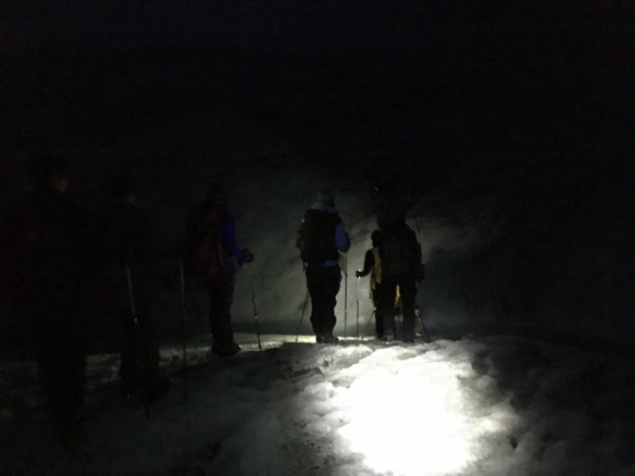
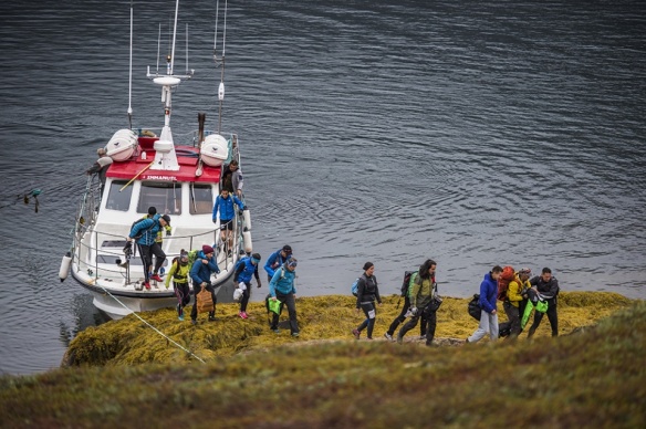
One boatload of people – that’s all who was brave crazy enough to want to do the 35 km KangNu race this year. Photo by: Leiff Josefsen for this Sermitsiaq.ag news article.

kangnu_2016_02_start 8:00 – We’re off! Photo by: Leiff Josefsen for this Sermitsiaq.ag news article.

9 HR 29 MIN 35 SEC OF ONE FOOT IN FRONT OF THE OTHER

It’s a long time to be at the same activity, the same action. Something around 53000 steps. Zoning out was not an option as traversing Greenlandic terrain takes awareness and concentration.

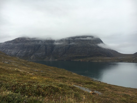
The boulders along the beach are huge and rough and sharp, and if they’re wet or covered in seaweed and moss, as many were on race day, one incorrect step could go horribly wrong. The hills are covered in soft moss and a crowberry & blueberry ground cover that is deceptively soft, so one always has to take care not to hyperextend a knee or roll an ankle. And there is no red carpet path cut for you – sometimes one really has to use their nature-sense to search for the route, for example to look for places where the grass is flattened a bit from runners that have already passed through.

HAPPINESS, FRUSTRATION, ACCEPTANCE, AGONY, SECOND-WIND, PRIDE, GRATITUDE

This was the gamut of high and low feelings I went through in the course of the race.

Happiness – The first 2.5 hours were absolutely lovely – the view running into the bottom of the fjord was stunning, and the air was fresh. The terrain was exactly as I expected it to be, and I settled into a nice pace. While I didn’t set any sort of goals for myself for this run in terms of time or pace, I had always generally envisioned that I would run the whole way, nice and easy, if the terrain was just like this.

IMG_3398 The enjoyable terrain to run on – slightly rocky, slightly soft groundcover of crowberry and blueberry, with steady elevation maintenance. The first 5-8 km.

Frustration – But the terrain was not just like this forever. At some point when we were uphill, a boat of judges sailed next to us in the fjord and shouted up to come downhill to run along the beach.

Nice white sandy beach? Not a chance. It was rocky and slippery, eventually turning into humongous boulders way larger than my body size. At first I could run on the rocks because they were small, thanks to my new Salomon Speedcross 4 shoes, but eventually it turned into one part walking, one part running as I grew more and more uncomfortable, getting scared to land wrong on my foot. I was getting so frustrated at the terrain, feeling it was hindering all my mental preparation of planning to run the whole way.

IMG_3406 The hellish terrain to run on – wet rocks that only got bigger and tougher in time, with gaining elevation. The next 5-8 km.

Acceptance – But for me, an inexperienced terrain runner, it wasn’t possible for me to run on the beach anymore, and I slowed to a “purposeful walk”. I had so much wish to run, but I just couldn’t. Eventually I accepted that I will just have to walk until we get out of the beach area, whenever that is… Somewhere in this period I picked up my friend and Crossfit Inua teammate who was walking a bit behind me, and we continued the rest of the way together, which I was so thankful for because, looking back, I don’t think I was mentally prepared enough to run this race alone.

Turns out it was another 2 hours nearly to get off the beach, only to be followed nearly immediately by a large uphill rocky stretch that was so steep there was a rope to guide the way. So the walking continued.

Agony – After coming through the first 15 km / 9 mi of the route along the rocky “beach from hell” and the uphill climb through the rocks, my hips were basically dead, and every step felt like fire. There were a few big steps up in the rocky uphill climb that I was nearly having to help lift my own leg up. It was somewhere along here that we picked up another friend and Crossfit Inua teammate who had been ahead of us, so then we were 3.

When we got to the start line of the 20 km / 12 mi KangNu race, it was a welcome and familiar sight because I knew the route from here, and I knew terrain was easy-cheesy compared to the previous.

Again I had so much wish to run – mostly to avenge the walking stretch – but my hips were simply in too much pain. I was getting frustrated and angry again that I used so much energy on the first stretch, that by the time I got to where it was possible for me to run, I couldn’t. Every single step for the next hour and a half was painful and slow-going. When we reached the second uphill climb of Ukkusissat Kangilequtaat, there was a silent pep-talk in my head for every single step. Take a step. One more. Another.

IMG_3411 Smiling and having fun was the only way to get through it. Heading uphill on Ukkusissat Kangilequtaat. Somewhere around the 20th km / 12th mi.

Second-wind – When we got to the top of the hill, there was a refuel station with chocolate, oranges, power bars, and juice – the first we’d encountered in maybe four hours’ time, although we had our own personal stocks in our backpacks, too. Having this extra fuel, plus knowing the 10 km left in the route were all downhill from here, was a boost for us, and we started to run. My hips were definitely still on fire, but the angle of running downhill changed the pressure, and I was able to run through it.

Not to mention, we suddenly saw ahead of us a group of 4 people hiking – they were the last of those who chose the 20 km KangNu hike. It was a self-centered yet soooo-needed mental boost to know that we had been through 15 km more terrain than them and still had enough gas to forge ahead past them. We eventually saw and passed another 5 hikers when we got closer to town.

IMG_3412 The downhill home stretch has really beautiful and dramatic nature. 

Pride – When we got to the final meters of the home stretch to Inussivik sports hall, we could hear music playing, and suddenly the MC’s were saying our names over the loud speaker to announce we were coming into the finish line. I was getting goosebumps thinking, “We actually did it!!” I truly was in shock and disbelief that I came through it.

It was such a big experience to cross over the finish line with my friend while giving her a high five, and to see our third friend waiting there, who had finished 3 minutes before us. It was a feeling of accomplishment and pride that I’ll never forget.

IMG_3421 KangNu 35 km complete!

Gratitude – The day after the race I was actually in way better recovery shape than I would have guessed. Still a bit swollen and tender in my hips, but with perfectly fine knees and ankles, and not a single blister on my feet!

Mostly I was so happy to have had the opportunity to try such a run and to have had two friends by my side. I wrote this on Facebook that day:

We talk frequently about PR’s in CrossFit – one kilo more, maybe five. These numbers are big and a lot to be proud over, and that I am, when they happen, but what I experienced yesterday gave me a much greater feeling of pride, which I will live off of for many years.

Yesterday I stepped outside the comfort zone; I moved my limits. I am not a runner, nor am I a terrain runner. I have only done such a run once before, and that was in 2014 for the KangNu 20 km / 12 mi. And, not to mention, a few weeks ago I was even fighting mentally to get through 5 km / 3 mi on the treadmill. But for some reason I thought I should try the KangNu 35 km / 21 mi in 2016. Maybe because I think I’m generally in good shape. Was that dumb? No. It was insane.

Therefore, when I crossed the finish line yesterday together with two of my super strong CrossFit friends (and let me be clear, I only crossed the finish line because they were there with me), I got a PR of 15 km’s / 9 mi’s run out in the most beautiful but harshest nature. It’s nearly incomprehensible for me.

That I will remember as, until now, the biggest personal challenge I have ever overcome.

Today’s going to be a good day

THE SAME THREE THOUGHTS RUNNING ON LOOP + A SONG

Due to the necessary situational awareness one needs when running in the backcountry, I was mentally present the whole time, and I kept coming back to the same few ideas. One was:

“There’s a finish line at the end of today’s race, but the purpose is not to cross it. The purpose is to enjoy all the steps it takes to get to it.” – Words I wrote on Facebook after being totally inspired by a Tree of Life film clip just before going to sleep the night before the race

So many times I was “waking myself up” to stop for a minute to look around at the indescribably beautiful country I am privileged to call home. I was thinking, Of course I will sail in this fjord maybe one hundred more times in my life, but will I ever be in this spot running again? Probably not. NOW is the time to appreciate this experience. “

* / * / *

The second was:

“Every once in a while one needs to move his/her boundaries. You can do it.” – Motivational words written to me by a friend, on the morning of the race

Original: “Man skal jo engang imellem flytte sin grænser. Sapinngilatit.”

There were many times I was feeling that I was really overstepping my boundaries of what is realistic for me based on previous experience. As I’ve said, I’ve only done trail running once before, (read here about my experience two years ago for the KangNu 2014 race), and that was the much easier and shorter 20 km / 12 mi KangNu route, so maybe a 15 km / 9 mi increase through much tougher terrain was too much of a jump?

But then I rationalised, if I thought the idea of a 35 km terrain run was just completely impossible for me, I never would have considered it in the first place. So the very fact that I considered and decided upon it, means I subconsciously always believed I could do it.

I also rationalised that others, like my friend who wrote to me, must have also believed I could do it. Not a single person questioned, “Are you sure? Do you really think you can do that?”  when they heard I will go for the 35 km route.

* / * / *

Finally, the third was:

“You are her happiness”. – Words written to me by a family friend about me & my mother.

I thought frequently of my mother, who is a paraplegic due to Multiple Sclerosis and who, over the course of the last 30+ years, has acquired more and more machines to carry out basic functions, the latest being a breathing vent.

I was thinking about how I use my body so much – daily CrossFit training, hiking, and special events like Inua Challenge and KangNu – while she’s sitting there not even able to lift her own hand. The contrast of my life versus hers is astounding.

I’ve always sort of scoffed at people who ‘run in the honor of…’ or ‘run in the memory of…’ people, but I get it now. Every time I came to think of these words by the family friend, I thought also, “I will complete this for her, to be her happiness.”

And the song? Taro by Alt-J.

NO INSTANT REPEATS

I am really glad that I stuck with it and somehow squashed the voice that screamed to me to back out. Crossing the finish line was a true moment of completely obliterating any physical limitations I thought I had, and taught me something about my own strength.

Will I do the 35 km KangNu terrain run again? No, never. Ironically, to now know the terrain that lies ahead means I’ll never get through it again.

Will I do some other physical challenge that presses me just as much, or more? Absolutely. Eventually. Maybe hike the 160 km / 96 mi Arctic Circle Trail between Kangerlussuaq and Sisimiut… maybe run/hike the 120 km / 72 mi Nuuk-Kapisillit terrain race… maybe run the Nuuk Marathon…

But with winter coming, and being that I’m not a downhill or cross-country skier, I think my opportunities for outdoor challenges have run their course for 2016. I’m more than satisfied to call the 35 km KangNu race my final physical accomplishment hoorah for the year.

Hiking In Greenland – Kingittorsuaq Mountain in Nuuk


Beginning to scramble/use hands on the way up. Photo by: Raven Eye Photography – Visit Greenland

The rush you get standing on top of a mountain is a special kind of adrenaline. Photo by: Raven Eye Photography – Visit Greenland

IMG_0664

KINGITTORSUAQ is proof that there’s BIG adventure in Nuuk, the Arctic Metropolis of Greenland. It is one of the four mountains in the city’s immediate vicinity that most residents know by name. (The other three are: Ukkusissat, Quassussuaq and Sermitsiaq). While most locals will take Ukkusissat as a Saturday morning or even after-work fun trip, sometimes you just want something a little more extreme.

SEE TO THE BOTTOM FOR SOME QUICK BITS ABOUT WHY KINGITTORSUAQ IS MORE DIFFICULT YET MORE EXCITING THAN THE STANDBYS.

My Hike on Kingittorsuaq

Three weekends ago (on 18 June 2016) I had the privilege to hike Kingittorsuaq mountain for the second time. The first time I hiked it was back in June 2012, so that shows you how infrequently this opportunity tends to come along without special circumstance.

Here’s some photographs from the trip. I think the two best experiences of the whole day were 1) cresting at the ‘saddle’ for a view over snow-capped peaks that even fooled Greenlanders into thinking it was the tough and rugged mountains of East Greenland, and 2) taking a quick polar plunge in a little meltwater swimming hole near the summit!

IMG_0623
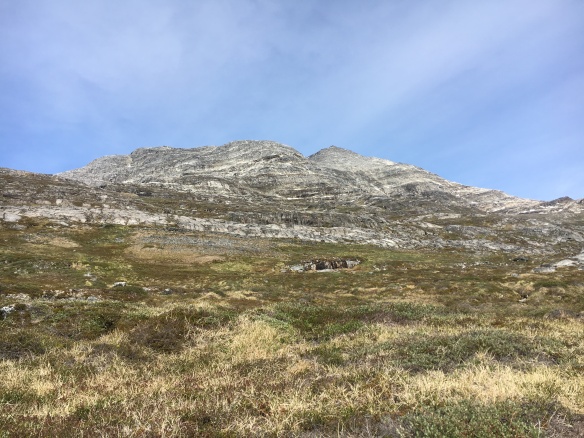
Hiking from sea to summit is no small feat. Sometimes one thinks, “Can I REALLY do this?” The answer is Yes, you can! Just put one foot in front of the other. The bottom half of the mountain is grassy/mossy/shrubby terrain, which I personally think is tougher on the legs than the rocky part.

IMG_0625 
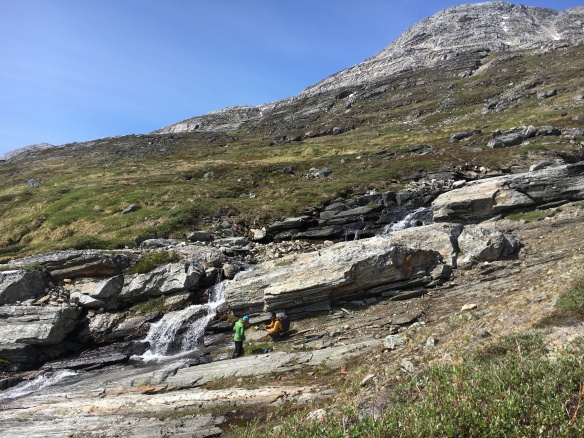
And anywhere there’s lush green terrain, there’s fresh running water sources. It’s special about Greenland to be able to drink directly from a stream or waterfall. Here we are at approximately 219 m / 719 ft above sea level.

IMG_0639 
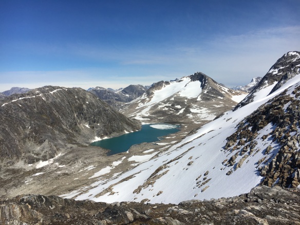
Spectacular outlook point from the saddle at approximately 800 m / 2625 ft above sea level. This is the shot that made some locals think it was East Greenland! The first of two best experiences of the whole day.

IMG_0654
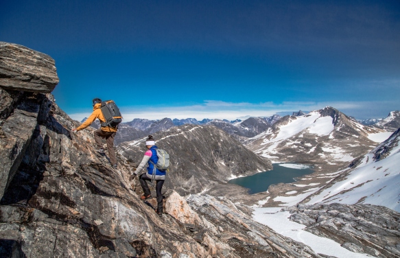
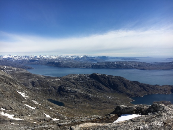
Here solidly into the rocky terrain, between 800-900 m / 2625-2953 ft above sea level, looking southward. It’s scrambling / bouldering from here on up, with more than a few narrow passes.

IMG_0656 
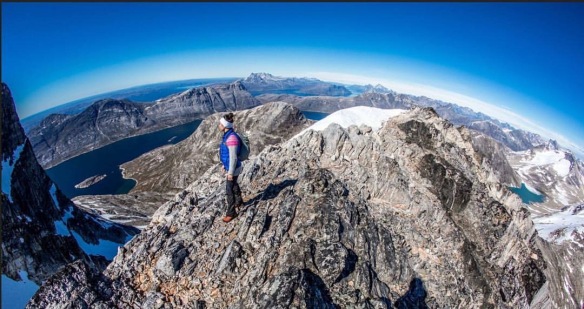
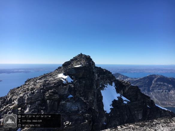
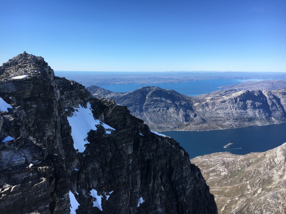
My favourite perspective, actually. There’s something about the steep wall of Kingittorsuaq in the foreground, Kangerluarsunnguaq fjord in the middle ground, and Nuuk Fjord beyond. You can see everything. Approximately 1169 m  / 3834 ft above sea level. 

IMG_0665 
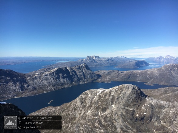
So beautiful and clear day. Feels like you could see all the way to Canada. Looking north into Nuuk Fjord. Four hours into the hike.

headstand kingittorsuaq 
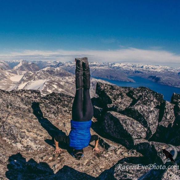
Beautiful overlooks deserve a yoga moment. Photo credit: Raven Eye Photography.

alpine swim kingittorsuaq
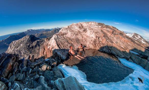
And little ponds of snowmelt deserve a quick dip. No, it wasn’t the slightest bit warm, but sometimes you just know when you’re NEVER going to get the same chance again, so it’s now or never. The other best experience of the entire day. Photo credit: Raven Eye Photography. 

So there you have a digital tour of hiking Kingittorsuaq in Nuuk, Greenland. Want some more info to decide if Kingittorsuaq is right for you? Read below.


Why Kingittorsuaq is more difficult than Ukkusissat:

  • It’s taller by approx. 410 meters / 1345 feet. (Ukkusissat is 780 m / 2559 ft and Kingittorsuaq is 1190 m / 3904 ft).
  • The top half (rough estimate) is pure bouldering/scrambling (i.e. you must use your hands to climb up) and, in some places, involves some “tight rope walking” along narrow passes.

Nearly to the true summit of Kingittorsuaq. The left picture is a view northward into Nuuk Fjord. The right picture is a more westward view; Nuuk city is behind the mountain in the middle ground, Ukkusissat.

  • There is no marked route, no slightly-trodden trail. You should absolutely go with someone who knows the way.
  • There are a lot of (sharp) loose stones and rocks in the top half. You must constantly pay attention to your hand placement and footing, and as one of my hiking partners noted, the conversation definitely dies down a bit as everyone starts concentrating more.

Why Kingittorsuaq is more exciting than Ukkusissat:

  • Kingittorsuaq one of the less-hiked mountains in Nuuk, so there’s absolutely a feeling of exclusivity and remoteness. The first time I hiked it, our group of 3 women + 1 man was the only group out there. This time, our group of 2 women + 3 men met just one other group: 4 men.
  • There’s a built-in sailing experience to get to the starting point. Unless, of course, you want to start with a 30 km walk or run through the Nuuk backcountry and Kangerluarsunnguaq lowlands – which, by the way, IS a thing. It’s called the annual KangNu Race, which I have run twice, both in the short version and in the seriously hard long versionTo sail to Kingittorsuaq like most people, you have the option of hiring a boat charter via Nuuk Water Taxi and then hiking on your own, or the other option is to purchase the experience as a ‘tour’ from a local operator, either Nuuk Adventure or Inuk Expedition.

IMG_0621 
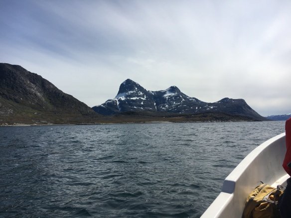
Kingittorsuaq is the double-peaked mountain. The left peak is, clearly, the higher of the two and is the true summit.

What to wear/bring with you in your daypack (NOT an all-inclusive list):

  • Breathable/ quick-dry layers, never cotton. Being able to regulate your body temperature ever so slightly with several thinner layers is infinitely more valuable than having one or a few thicker layers. For this particular day (light wind 10 m/s or less, air temperature around 5-10*C) I wore long running pants, a breathable short-sleeve shirt, a lightweight wool-blend long-sleeve base layer, a lightweight wool sweater (which came off and on periodically), and a ultra lightweight vest. Also a thin Buff headband. At some points I did take on a pair of gloves when I could feel my fingers were a bit slow reacting. It’s also good to have an extra pair of wool socks, and at least one extra layer along with you as backup.

IMG_0661 
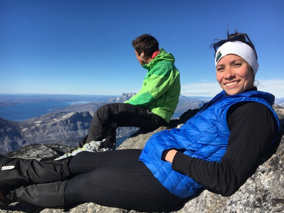
Taking in the sights at 1170 m / 3842 ft on Kingittorsuaq. FANTASTIC view over the entire world, it feels like. Note the clothing.

  • Sturdy hiking boots with good ankle support, preferably waterproof. Good footwear simply cannot be stressed enough for hiking in Greenland. The granite in these mountains is rough and sharp, and it’s not really an exaggeration to say that it can eat the soles (and souls) of cheap or old hiking boots.

FullSizeRender 3

  • Lunch. It can take a fitter-than-average person around 4 hours to reach the summit, plus nearly the same amount of time to get back down, so you will want to have plenty of energy store. Don’t let yourself get hangry. Chocolate and nuts are always good mountain snacks, but a slab of smoked Greenlandic reindeer meat is also perfect for the trip. When in Rome…
  • Water bottle. There are several places to collect fresh drinking water directly from runoff streams, and it tastes so refreshing!
  • Hat and gloves. Yes, even in summer a light wind can make it quite cold. It’s especially important to protect the dexterity of your hands given how much bouldering/scrambling you’ll be doing at higher altitudes.
  • Gaiters. Useful at the bottom half when traipsing through low brush and at the top half if there should be any snowy patches. At the very least, they can be an extra layer of lower-leg protection against mosquito bites.
  • Mosquito net hat. Speaking of… Arctic summers are notorious for mosquitoes and flies, and they can be especially gruesome when there’s little or no wind.
  • Sunglasses and sunscreen. High latitudes plus high altitudes are the perfect combination for getting a lot of color on your face in just a few hours. Add in the sun’s reflection off of snow, and you’ve got a perfect combination for sunburn. Protect your skin and eyes!

How to Get Here

  • Fly through ICELAND.
    • Air Greenland flies direct from Keflavik International Airport to Nuuk International Airport (3 hour flight).
    • Air Iceland Connect flies direct from Reykjavík Domestic Airport to Nuuk International Airport (3 hour flight).
  • Fly through DENMARK.
    • Air Greenland flies from Kastrup/Copenhagen International Airport to Kangerlussuaq International Airport in Greenland (4 hour flight) and then on to Nuuk International Airport (1 hour flight).

For more hiking inspiration and information, ready my Ultimate Greenland Hiking Guide on visitgreenland.com.

Follow @Polarphile on Instagram!

Follow me on Instagram at @Polarphile to see what my daily life in Nuuk, Greenland looks like!

Here’s a few snapshots from the last week:

Celebrating the Return of the Sun in Ilulissat, plus 4 Things I (Re)Learned About Greenland Doing It

IMG_4974  Southerly view over the Ilulissat Icefjord toward the sunrise, standing at Seqinniarfik. Photo taken: 13 Jan 2016.

First sunrise in 6 weeks

Yesterday the sun rose above the horizon in Ilulissat for the first time in six weeks. Do you remember where you were or what you were doing on 30 November last year? Probably not; it feels so long ago. Now imagine that you have not set eyes on the sun – the very thing you’re taught not to look directly at – since that day.

Needless to say, there’s a bit of a celebration in Ilulissat to bid the sun welcome back. Schools and offices close early, and everyone trudges in one way or another out to a viewpoint called Seqinniarfik in the UNESCO World Heritage Site to watch the sun come up over the mountains on the south side of the Ilulissat Icefjord, take a small skip across the sky, and go down again a mere 52 minutes later.

I joined the masses out there on the hill and was so happy the share the time surrounded by people. Much like most of my experiences in Greenland, it was an instant renewal of my appreciation for the country and a reminder about these 4 things I’ve come to learn about Greenland over time.

DSCN2786 
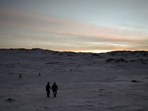
Starting out toward Seqinniarfik. Check the tiny dots (people) on the top of the hill! And that’s not even the final spot. Photo taken: 13 Jan 2016


1) Nothing comes on a silver platter

A nicely-plowed plank boardwalk all the way from the road up to Seqinniarfik could have been a dream, but this is Greenland, where even a well-defined sidewalk in town is sometimes too much to ask.

The route to Seqinniarfik was through sled dog territory and over natural terrain, perfectly easy to clear in summer but slightly challenging in winter conditions. The snow was crunchy sheets that didn’t always hold my weight, sending me sinking into knee-deep snow beneath. The high winds of the last two weeks continued and were so strong at my back it gave me a pressure headache and made me dread having to walk into the force on the way home. I didn’t dare to grab my camera out of my pocket for fear of either dropping it or, much worse, having one of my precious sealskin mittens blow away in the midst of a juggling maneuver.

Of course, I did dare because I just had to take a picture, but after even just a few minutes with gloves off, your fingers start to lose mobility to even press the shutter button. Then you have to make the really difficult choice between ‘getting the shot’ (or taking a selfie, let’s be honest) and feeling like you might lose an index finger. All mittens stayed thankfully in my possession but the minus temperatures rendered both my iPhone and digital camera frozen in place after a mere four or five times coming out of my pocket.

No, it’s not always a piece of cake to get out into the Greenlandic nature in winter, but it sure is worth it once you’re there.

 IMG_4976 Seqinniarfik selfie. At the top. Photo taken: 13 Jan 2016.


2) There are no words for how stunning Greenland is

Sometimes you can sit looking at the Greenlandic landscape and you could just cry. I have said this myself, and I have heard tourists say it, too. It is a natural reaction when you have so many impressions and feelings swirling around in your body that can’t get out in a normal way with thoughts or speech. Instead, they jump out themselves in a most physical manner.

This country is breathtaking and incredible. The nature is pure and raw and strong and powerful. In pictures I have seen other places that the world calls beautiful, maybe because they are colorful or peaceful, and I always think to myself, ‘Did those places challenge people’s willpower, make them stronger, and generally put humanity to the test?’ To me, that is beauty.

Greenland is not beautiful despite its extreme conditions. It is beautiful because of them.


3) The weakest Greenlander is still stronger than the average person

If someone had a mere single breath in him or her, they made an effort to reach Seqinniarfik, it seemed. It was not only the young school kids skating around in their high top sneakers on the icy rocks and holding their thin jackets overhead like sails in a summer breeze.

Not even poor physical condition could keep some people away from the hill. I saw older people out there walking through the snow at a pace of maybe two kilometers an hour, one foot in front of the other, but determined nonetheless to see the first sunrise in six weeks. I even saw a woman on her motorized scooter at the end of the road waiting, hopefully, for someone to pick her up on snowmobile. One could imagine they have done this every year for their entire lives. One could imagine this was maybe one of the few times they got out into the nature anymore.


4) Greenlanders do appreciate their own nature, even on the 25000th day

I have heard tourists speculate sometimes that Greenlanders probably forget how fantastic the landscape is since they see it day in and day out, coupled with their observation that Greenlanders rarely exclaim “Oh my gosh! How pretty!” and “Look at that!” toward things a tourist definitely would point out.

On the contrary, living close to and appreciating the nature is an innate element of Greenlandic culture. Regardless of whether one is in the biggest city in the country or in the smallest settlement, the nature is always there and always central to life. Greenlanders can be a people of few yet profound words, hence the lack the exclamations, and my own friend explained this very phenomenon in exactly this style.

She said, “Why ruin the moment with words about something that is already obvious?”

Touché.

DSCN2789 View over Ilulissat. Photo taken: 13 Jan 2016.

Cooking Suaasat, a Traditional Greenlandic Seal Soup Recipe

DSCN1386

When life gives you a bag of seal meat, make suaasat!

Suaasat is a traditional soup whose main ingredient is seal meat. It looks heartier than any stew I’ve ever seen and packs a distinct flavor punch like Arctic blood.

Many will say it is “old Greenland” food, and that’s probably true. I don’t think I’ve ever seen suaasat served in a restaurant, which would surely opt for a more modern carpaccio preparation instead. Not to mention, it most likely would not be the top seller on the menu as people who have not grown up with the tradition tend to think it’s an… acquired taste.

But I like it, and I approach suaasat like its French cousin, the Vichyssoise. Just because you don’t eat it on the daily doesn’t mean you cannot know how to make it.

So when some fresh seal meat more or less fell into my lap one day, I think my inner Inuit chef was screaming my name.

How does seal meat fall into one’s lap?

There’s a whole Facebook group dedicated to buying and selling things in Nuuk – clothes, housewares, skis, boats, puppies, and even food goods. I saw that my friend/colleague put up for sale bags of seal meat that her boyfriend had caught himself, so I jumped on the chance to buy some. If you’re not a hunter yourself, one usually just buys seal meat at Kalaaliaraq, the fresh Greenlandic market in city center, but it’s much more fun to get it from someone you know!

I wasn’t totally sure what use I would put my seal meat to, until an opportunity presented itself to learn how to make suaasat. So one evening, my American friend and I made ourselves cozy while her Greenlandic husband taught us about this recipe.

Suaasat Recipe

Cookware:

1 large stock pot
1 slotted spoon
1 shallow bowl

Ingredients:

1-1,5 kg (2-3 lb) seal meat, bone in
cold water
salt and pepper, to taste
4-5 handfuls white rice
1 large white onion, chopped
5-6 potatoes
spicy mustard

Directions:

Trim excess fat from the seal meat, leaving some on for flavor.

Fill a stock pot 2/3 full with cold water and place seal into the water.
Season with salt and pepper, and bring to a boil for 30 minutes. You will notice how the water almost instantly takes on the dark color of the meat.
The blood and fat from the seal will rise to the surface and create a foamy layer. Stir occasionally.

DSCN1377

Add the rice and onion to the boiling pot and continue to boil for 10 minutes.

Add the potatoes and continue to boil for 20 minutes.

DSCN1380

After approximately 1 hour total cooking time, the suaasat should be ready. Using a slotted spoon, remove the seal from the pot and place into a shallow serving dish. Serve the soup alongside the meat, and with mustard on the side.

DSCN1383

Takanna!

(That’s Greenlandic for Dig in!)

Experience Greenland on board Icelandair!

IMG_9262

Are you flying on Icelandair soon? No, the airline unfortunately has not yet decided to fly to Greenland, but you can still experience Greenland on board in two other ways!

1) Get inspired by this “Tip of the Iceberg” article about nature, gastronomy, and culture in Greenland on page 42 of Icelandair Stopover (summer 2015 edition).

2) Just look out the window! If you’re flying between North America and Europe on a day with clear skies, you can see Greenland from 30000 feet for approximately 45 minutes, and IT. IS. BREATHTAKING. Like this! (I’ve done this maybe 15-20 times and I’m still glued to the window for every second.)

DSCN2174First sign of Greenland! Sea ice off Greenland’s east coast, as seen from a westbound Icelandair summer flight, 45 minutes after takeoff from Reykjavík, Iceland. Time: 1815 UTC. Watch the LIVE video here!

DSCN2190Superglacial lakes making the Greenland Ice Sheet look like Swiss cheese, as seen from a westbound Icelandair summer flight, 60-70 minutes after takeoff from Reykjavík, Iceland. Time: 1840 UTC.

DSCN2198 Finally, the white gives way to blue and tan again. Greenland’s west coast, as seen from a westbound Icelandair summer flight, 90 minutes after takeoff from Reykjavík, Iceland. Time: 1900 UTC. Watch the LIVE video here!

FYI: It is much more common to be able to see Greenland on a westbound flight than an eastbound flight. Part of this is due to the time of day. Westbound flights typically depart in the evening (17:00) from Reykjavík and fly into the sunlight. By contrast, eastbound flights typically depart in the late evening (20:00 from east coast USA, 16:00-17:00 from west coast USA)  and fly into the darkness. Another reason is due to the flight route. For reasons unbeknownst to me, the westbound flights tend to reach higher latitudes (61*N – 64*N) more often than the eastbound flights, which just barely reach the southern tip of Greenland (59*N).

FYI: It is much more common to be able to see Greenland in spring and summer than in autumn and winter. In late autumn and winter, the sun has usually set too low to be able to see much, even though you’re flying into the sun. But in spring and summer, there is plenty of sunlight to illuminate super Greenland!

Are you interested to see more footage of Greenland’s landscape from the air? See my Through the Airplane Window: Videos of Flying in Greenland post!

Through the Airplane Window: Videos of Flying in Greenland

DSCN2121

Come fly with me!

Do you like flight videos? Are you the kind of person that likes to visualize what it looks like to land in a country before you travel there? Are you just daydreaming of Greenland?

Well, if you can look past the foggy windows (figuratively, that is) and, at times, shaky filming, then these videos of landing and taking off from various airports and heliports around Greenland (and at different times of the year) can give you the right impression that Greenland is the most majestic place on this earth!

Disclaimer: Every time I shoot one of these videos, I have the highest and most earnest hopes to edit them, add great music, etc. but it just never happens. So I’m abandoning those dreams and simply putting the videos here in their rawest form – take it or leave it! 🙂

The videos are ordered alphabetically by town name.

Illorsuit

Late Spring arrival to Illorsuit, Greenland via Air Greenland (settlement in North Greenland)

Ilulissat

Late Spring departure from Ilulissat, Greenland via Air Greenland (town in North Greenland, International Airport)

Kangerlussuaq

Late Spring arrival to Kangerlussuaq, Greenland via Air Greenland (settlement in Destination Arctic Circle, International Airport)

Kulusuk

Late Winter arrival to Kulusuk, Greenland via Air Iceland (settlement in East Greenland, International Airport)

Mid Spring departure from Kulusuk, Greenland via Air Iceland (settlement in East Greenland, International Airport)

Early Summer departure from Kulusuk, Greenland via Air Iceland (settlement in East Greenland, International Airport)

Narsaq

Late Winter arrival to Narsaq, Greenland via Air Greenland (settlement in South Greenland)

Narsarsuaq

Late Winter arrival to Narsarsuaq, Greenland via Air Greenland (settlement in South Greenland, International Airport)

Nugaatsiaq

Late Spring arrival to Nugaatsiaq, Greenland via Air Greenland (settlement in North Greenland)

Nuuk

Mid Winter departure from Nuuk, Greenland via Air Iceland (capital city, International Airport)

Late Spring arrival to Nuuk, Greenland via Air Greenland (capital city, International Airport)

Qaarsut

Late Spring departure from Qaarsut, Greenland via Air Greenland (settlement in North Greenland)

Qaqortoq

Late Winter arrival to Qaqortoq, Greenland via Air Greenland (town in South Greenland)

Tasiilaq

Early summer departure from Tasiilaq, Greenland via Air Greenland (town in East Greenland)

Uummannaq

Late Spring arrival to Uummannaq, Greenland via Air Greenland (town in North Greenland)

Greenland Ice Sheet

Mid Winter flying over East Greenland and Greenland Ice Sheet via Icelandair (no landing)

Early Spring flying over Greenland Ice Sheet and West Greenland via Icelandair (no landing)

Early Summer flying over West Greenland via Icelandair (no landing)